Zion Narrows
Zions Park
Maps - Zion National Park (U.S. National Park Service) - http://www.nps.gov/zion/planyourvisit/maps.htm
Zion Park Map - Zion-Park-Map-Website.pdf - http://www.nps.gov/zion/planyourvisit/upload/Zion-Park-Map-Website.pdf
Zions Narrows
Zion Narrows Map and Planner - http://www.zionadventures.com/zion-narrows/maps-a-logistics/zion-narrows-map/
FREE Zion Narrows Map and Planner
http://www.zionadventures.com/images/stories/Narrows2010/TripPlanning/narrowsmap2010-V-web.pdf
-
- Zion Narrows - Wild Backpacker - http://wildbackpacker.com/destination/zion/zionnarrows.html
- Zion Narrows Hike | Utah.com - http://www.utah.com/nationalparks/zion/zion_narrows.htm


Narrows Map - http://www.utah.com/nationalparks/zion/zion_narrows_map.pdf
-
Route 66 » zion narrows - http://dancingweasel.com/route66/?tag=zion-narrows


-
http://www.gtmportfolio.com/art_utah_zion.html

-
Zion National Park - Hiking The Narrows (incl. a map) with travel guide including photos and descriptions of other Zion National Park hiking trails. Pictures of the Narrows (National Geographics list of America's Top 100 Adventures). - http://www.americaswonderlands.com/exploringzion.htm
-
Joe's Guide to Zion National Park - Zion Narrows Hiking Guide - http://www.citrusmilo.com/zionguide/zionnarrows.cfm
No cotton!
- Trail runner shoes - http://amzn.com/B005DLX4VI or http://amzn.com/B000FDYFOE
- Good socks (neoprene) - http://amzn.com/B003BUIZG2
- Hiking poles
- Drybag
- Headlamp - Petzl E93 - http://www.amazon.com/gp/product/B0027GTFO2/ref=as_li_tf_tl?ie=UTF8&tag=joesguidetozi-20&linkCode=as2&camp=1789&creative=9325&creativeASIN=B0027GTFO2
-
GPS Map of Zion National Park - http://www.travelbygps.com/premium/zion/zion.php
GPX - http://www.travelbygps.com/gpx/Zion.gpx
-
Zion Narrows - http://www.zionnational-park.com/zion-narrows.htm
GPS Coordinates - WGS84 Datum
Zion Narrows
North Fork Road Crosses Over North Fork of the Virgin River: 37°23.4400N 112°49.5400W
Gate at Chamberlain Ranch: 37°23.3950N 112°49.9830W
Parking at Narrows Trailhead: 37°23.1200N 112°50.3230W
-
Joe's Guide to Zion National Park - Zion Narrows Hiking Guide - http://www.citrusmilo.com/zionguide/zionnarrows.cfm Zion Narrows map - map Zion Narrows - http://www.zionnational-park.com/map-zion-narrows.htm
-
Zion Narrows - http://www.zionnational-park.com/zion-narrows.htm
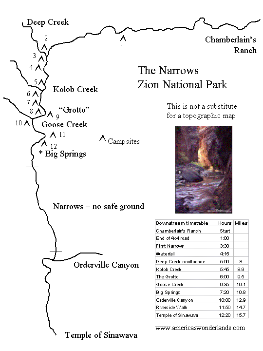
Zion Narrows - The road ends and a short beaten path drops into the river. The next 12 miles involves zigzagging in and out of the water so be sure to put all valuables into your dry bags. Keep eyes peeled on the right bank, during the next half-mile for a 50' jug handle arch. Beyond the arch, Navajo sandstone walls progressively elevate and several narrow sections begin to suggest the "flavor" to come. Soon, deep side canyons make their entrance and the first of twelve campsites are seen.
Waterfall - seemingly impassable waterfall is encountered about 7 miles into the hike but simply walk up the left embankment and pass through the cleft in the rock. Never jump off anything while in a canyon. Serious injuries have resulted in the past from hikers plunging from the top of the 20' waterfall into the pool below. As you continue down the canyon , high walls rise on either side and filtered sunrays cast shadows and reflect mystical colored light.
Deep Creek - The confluence of Deep Creek and the North Fork of the Virgin River appear at the halfway point of the hike. The new water from the side canyon almost triples the flow of water in your hiking path as it spills its crystalline, cold contents into the canyon. If you have not used hiking poles yet on this trip, now is the time.
Kolob Creek - Farther downstream Kolob Creek enters from the right and may possibly add yet more flow to the river "trail" depending on whether the Washington County Water Conservancy District is releasing water from the Kolob Reservoir for irrigation purposes or not.
Goose Creek - The next side stream is Goose Creek, which also enters from the right. Big Spring is a picturesque oasis, located just past Goose Creek, where water cascades through lush vegetation and tumbles to the river below.
Big Spring - This is a popular area to take a break and filter water for drinking for the rest of the hike. Nearly 11 miles into the hike, crowds that have hiked from the Riverside Walk start to appear. In this north-south running section of the Narrows the lighting is almost eerie. A glowing spectrum of orange, red and pink seem to radiate from within the rock itself. The most well known of the side canyons, Orderville Canyon, will be on your left, 2 miles down river. Expect this canyon to add a gentle flow of cold water to join the churning water you are now hiking in.
Orderville Canyon - This is a popular route that requires a permit but hikers can explore up the to the plaque at the first waterfall without one. A little over a mile farther Mystery Falls trickles down the steep side wall as the water from Mystery Spring escapes down the smooth rock face. Now with just a quarter-mile of river hiking left, crowds grow larger as curious tourists dabble in a short walk from the end of the Riverside Walk. Take this trail back to the shuttle or your awaiting vehicle depending on the time of year you have chosen to hike.
-
Hiking Around Las Vegas, Zion National Park, Virgin River Narrows - http://www.birdandhike.com/Hike/Zion/VR_Narrows/_VRNarrows.htm
Site # 	Location 	Latitude (°N) 	Longitude (°W) 	UTM Easting 	UTM Northing 	Elevation (feet) 	Verified
0863 	Zion Visitor Center 	37.2000 	112.9865 	323702 	4118706 	3,940 	Yes
0866 	Highway 9 at North Fork Road 	37.2391 	112.8331 	337398 	4122770 	6,010 	Yes
0867 	North Fork Road at Virgin River 	37.3904 	112.8249 	338450 	4139545 	5,970 	Yes
0868 	North Fork Virgin River trailhead 	37.3855 	112.8379 	337289 	4139019 	5,852 	Yes
Wpt. 	Location 		Easting NorthingElev	Time	Minutes	Dist	Verified
01 	Trailhead 		337290 	4139014	5,852 	0552 	0 	0.00 	GPS
02 	Canyon Begins to Narrow 335476 	4138004 5,704 	0618 	25 	. 	GPS
03 	Old Tractor 		335296 	4138087 5,693 	0621 	3 	. 	GPS
04 	Bullock's Cabin 	334778 	4137455 5,653 	0637 	16 	1.5 	GPS
05 	End of Road 		334214 	4137606 5,597 	0646 	9 	. 	GPS
06 	Feels like Zion Canyon 	333745 	4137491 5,551 	0653 	7 	. 	GPS
07 	Simon Gulch 		330724 	4137557 . 	0830 	11 	4.9 	.
08 	Canyon Widens 		330023 	4137611 5,374 	0819 	26 	. 	GPS
09 	NPS Boundary 		329336 	4137515 5,322 	0835 	5 	. 	GPS
10 	Campsite 1 Waterfall 	. 	. 	. 	0902 	27 	6.9 	.
11 	Deep Creek, depart 	327192 	4136302 5,323 	1010 	20 	8.0 	map
11 	Deep Creek, arrive 	327192 	4136302 5,323 	0949 	47 	8.0 	map
12 	Kolob Creek 		327286 	4135208 . 	1040 	30 	8.9 	map
13 	Goose Creek 		326695 	4134003 . 	. 	. 	10.1 	map
14 	Big Spring 		326685 	4133195 . 	. 	. 	10.8 	map
15 	Orderville Canyon 	327545 	4130589 . 	. 	. 	12.9 	map
16 	End of Riverside Trail 	327385 	4129356 4,480 	1540 	. 	14.7 	GPS
17 	Temple of Sinawava 	327417	4128082	4,420 	1610 	40 	15.7 	Yes
GPX: http://www.birdandhike.com/Hike/Zion/VR_Narrows/VRNarrowsTrlWpts.gpx.zip
--
Really old picture view of Zions and Maps

A Guide to the Trails: Zion National Park - http://alumnus.caltech.edu/~leif/camping/AGuideToTheTrailsOfZion.html
== Bottom
STOP AT BIG SPRINGS - "Bottom-Up hikers are required to turn around here. Backcountry travel in this section of river requires a Park permit." [1]